


24 km | 31 km-effort
![Trail On foot Stará Huť - [Č] Strž - Nečín - Photo](https://media.geolcdn.com/t/1900/400/45f89b58-cabb-4e58-9772-0518213db066.jpeg&format=pjpeg&maxdim=2)

Tous les sentiers balisés d’Europe GUIDE+


FREE GPS app for hiking
 SityTrail
IGN / Geographical institutes
SityTrail World
The world is yours!
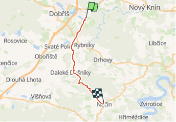
Trail On foot of 11.8 km to be discovered at Central Bohemia, Unknown, Stará Huť. This trail is proposed by SityTrail - itinéraires balisés pédestres.
Trail created by cz:KČT.
![Trail On foot Stará Huť - [Č] Strž - Nečín - Photo 1](https://media.geolcdn.com/t/2048/auto/d76c265a-4790-4c0f-becb-1921f3638842.jpeg&format=jpg&maxdim=0 "Trail On foot Stará Huť - [Č] Strž - Nečín - Photo 1")
![Trail On foot Stará Huť - [Č] Strž - Nečín - Photo 2](https://media.geolcdn.com/t/2048/auto/270ff546-473f-4084-9f62-1a3d2b61beb5.jpeg&format=jpg&maxdim=0 "Trail On foot Stará Huť - [Č] Strž - Nečín - Photo 2")
![Trail On foot Stará Huť - [Č] Strž - Nečín - Photo 3](https://media.geolcdn.com/t/2048/auto/b9ae9aa3-c20f-4158-810e-631ca3e99458.jpeg&format=jpg&maxdim=0 "Trail On foot Stará Huť - [Č] Strž - Nečín - Photo 3")
![Trail On foot Stará Huť - [Č] Strž - Nečín - Photo 4](https://media.geolcdn.com/t/2048/auto/857013b9-29f0-43da-a0cc-798f72e2e672.jpeg&format=jpg&maxdim=0 "Trail On foot Stará Huť - [Č] Strž - Nečín - Photo 4")
![Trail On foot Stará Huť - [Č] Strž - Nečín - Photo 5](https://media.geolcdn.com/t/2048/auto/61949bd9-f5ad-4a14-84a2-19fc4e4b4b96.jpeg&format=jpg&maxdim=0 "Trail On foot Stará Huť - [Č] Strž - Nečín - Photo 5")
![Trail On foot Stará Huť - [Č] Strž - Nečín - Photo 6](https://media.geolcdn.com/t/2048/auto/4e4c05f0-6e3a-4b76-be32-0813124178ea.jpeg&format=jpg&maxdim=0 "Trail On foot Stará Huť - [Č] Strž - Nečín - Photo 6")
![Trail On foot Stará Huť - [Č] Strž - Nečín - Photo 7](https://media.geolcdn.com/t/2048/auto/c129a138-d625-454a-a12c-b27c60e454f3.jpeg&format=jpg&maxdim=0 "Trail On foot Stará Huť - [Č] Strž - Nečín - Photo 7")
![Trail On foot Stará Huť - [Č] Strž - Nečín - Photo 8](https://media.geolcdn.com/t/2048/auto/45f89b58-cabb-4e58-9772-0518213db066.jpeg&format=jpg&maxdim=0 "Trail On foot Stará Huť - [Č] Strž - Nečín - Photo 8")
![Trail On foot Stará Huť - [Č] Strž - Nečín - Photo 9](https://media.geolcdn.com/t/2048/auto/37177b0d-30f6-4970-8bcc-1dc72195b683.jpeg&format=jpg&maxdim=0 "Trail On foot Stará Huť - [Č] Strž - Nečín - Photo 9")
![Trail On foot Stará Huť - [Č] Strž - Nečín - Photo 10](https://media.geolcdn.com/t/2048/auto/3122f9cb-ded6-4ba7-a6a4-e2e01a216c2a.jpeg&format=jpg&maxdim=0 "Trail On foot Stará Huť - [Č] Strž - Nečín - Photo 10")
On foot
![Trail On foot Dobříš - [Z] Dobříš - Kazatelna, okružní trasa - Photo](https://media.geolcdn.com/t/375/260/73d47d22-080a-4d13-9f9d-c09866c7d376.jpeg&format=jpg&maxdim=2)
On foot